
District Overview
Kalaburagi, formerly known as Gulbarga, is one of the prominent districts in the northeastern part of Karnataka. The district is known for its rich history, magnificent architecture, diverse traditions, and unique cultural heritage. Kalaburagi has played an important role in the history of the Deccan region and is home to several historic monuments, forts, mosques, temples, and other architectural landmarks.
The district is also known for its vibrant culture, educational institutions, agriculture, and growing business opportunities. Kalaburagi is particularly famous for its distinctive Kalaburagi Tur Dal, which has earned a geographical indication (GI) recognition. The city serves as an important educational and commercial center for the surrounding region, attracting students, entrepreneurs, visitors, and businesses from different parts of Karnataka.
Today, Kalaburagi beautifully combines its historic legacy with modern development. Improved infrastructure, healthcare, education, tourism, and commercial activities are contributing to the district’s growth. With its welcoming people, traditional cuisine, cultural celebrations, historical attractions, and emerging opportunities, Kalaburagi continues to develop as a destination that proudly represents the heritage and future of northern Karnataka.
Kalaburagi Through the Centuries
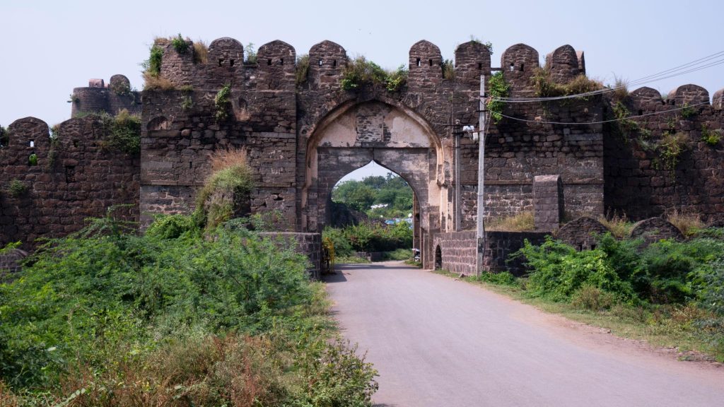
Kalaburagi has a history that stretches back to the 6th century CE, making it one of the historically significant regions of northern Karnataka. The region witnessed the rule of several powerful dynasties, including the Rashtrakutas, Chalukyas, Kalyani Chalukyas, Kalachuris, Yadavas, Hoysalas and Kakatiyas. These successive kingdoms contributed to the region’s political, cultural and architectural development.
A major turning point came in the 14th century, when Kalaburagi became the capital of the Bahmani Sultanate in 1347 under Alauddin Hasan Bahman Shah. During this period, the city grew as an important centre of administration, architecture, culture and commerce. The historic Kalaburagi Fort and Jama Masjid remain important reminders of this era, with their distinctive medieval Deccan architectural character.
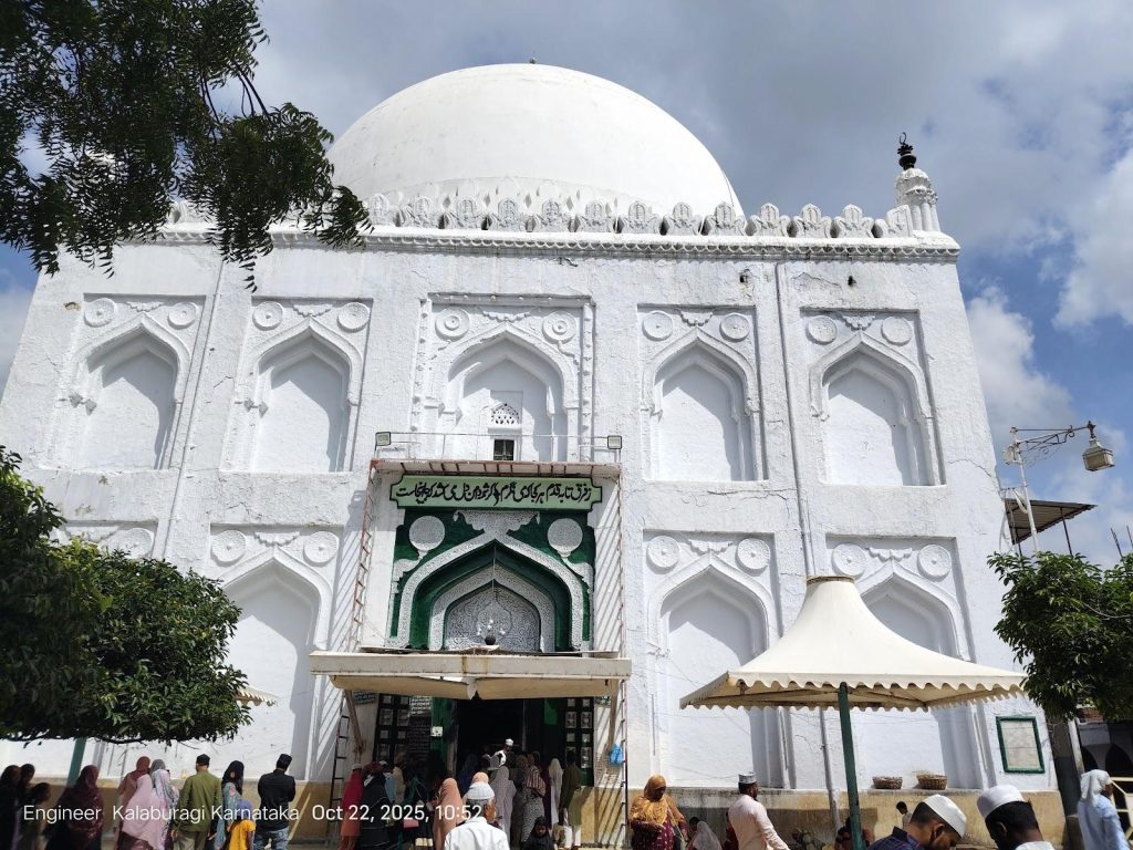
Kalaburagi is a vibrant centre of Deccan culture and traditions, where different communities and historical influences have shaped a unique cultural identity. The district is known for its historic monuments, traditional celebrations, local art, music, and architectural heritage. Important landmarks such as the Khaja Bande Nawaz Dargah, Kalaburagi Fort and Haft Gumbaz reflect the region’s diverse cultural and architectural legacy.
The district is also famous for its local cuisine and agricultural traditions, particularly the renowned Kalaburagi Tur Dal. Festivals, religious gatherings, traditional food, and community celebrations bring people together throughout the year. This combination of heritage, traditions, hospitality, and modern development makes Kalaburagi a distinctive cultural destination in northern Karnataka.
Culture & Heritage
Geographical Features of Kalaburagi District
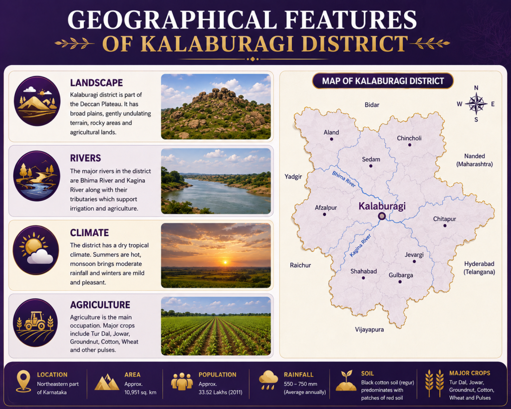
Kalaburagi District, located in the northeastern part of Karnataka, forms part of the Deccan Plateau and is characterized by broad plains, gently undulating terrain, rocky landscapes, and agricultural lands. The district has a predominantly dry tropical climate, with the monsoon bringing seasonal greenery across the region. Its geographical setting and fertile black soil make agriculture an important part of the local economy, particularly the cultivation of Tur Dal, pulses, cereals, and oilseeds.
- Latitude: 16°03′ N to 17°03′ N
- Longitude: 76°04′ E to 77°42′ E
- Area: Approximately 10,951 sq. km
- Average Elevation: Approximately 450–500 m above sea level
- Terrain: Broad plains, gently undulating land, rocky areas, plateaus, and agricultural fields
- Major Rivers: Bhima River and Kagina River
- Climate: Predominantly dry tropical climate with hot summers, seasonal monsoon rainfall, and comparatively cooler winters
- Soil Type: Predominantly black cotton (regur) soil, with red and other soil types occurring in some areas
Kalaburagi at a Glance – Demographic Profile
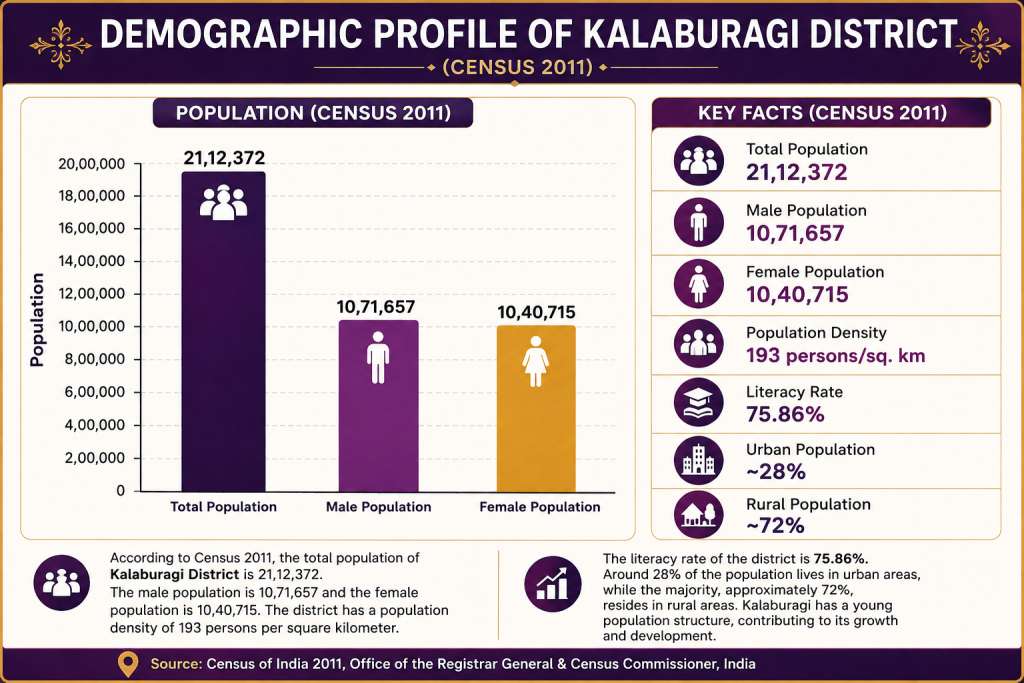
According to the Census 2011, Kalaburagi District had a total population of approximately 21.17 lakh, with males and females forming a nearly balanced share of the population. The district has a predominantly rural population, while Kalaburagi city and other major towns contribute to its growing urban population. This demographic composition reflects the district’s strong connection with agriculture and rural communities along with the gradual expansion of urban centres.
Kalaburagi’s population is supported by a diverse social and cultural environment, with education, employment, agriculture, trade, and public services contributing to the district’s development. The district’s literacy levels and expanding educational infrastructure continue to support social progress, while its growing towns and cities are creating new opportunities in business, healthcare, education, technology, and employment.
Statistical Overview of Kalaburagi District
| Statistic | Value |
|---|---|
| Area | 10,954 Sq. Km |
| Population (2011 Census) | 25,66,326 |
| Population Density | 234 persons / Sq. Km |
| Literacy Rate | 64.9% |
| Sex Ratio | 971 females / 1,000 males |
| Revenue Sub-Divisions | 2 |
| Taluks | 7 |
| Towns | 11 |
| Gram Panchayats | 264 |
| Villages | 918 |
| Rural Population | 17,30,775 |
| Urban Population | 8,35,551 |
| District Headquarters | Kalaburagi |
| Major Rivers | Krishna River, Bhima River |
| Major Soil Type | Black Cotton Soil (Regur) |
| Major Crops | Tur Dal, Jowar, Wheat, Cotton, Groundnut, Sugarcane |
| Major Irrigation Project | Upper Krishna Project |
| Official / Prominent Languages | Kannada, Urdu |
Revenue & Economic Overview of Kalaburagi District
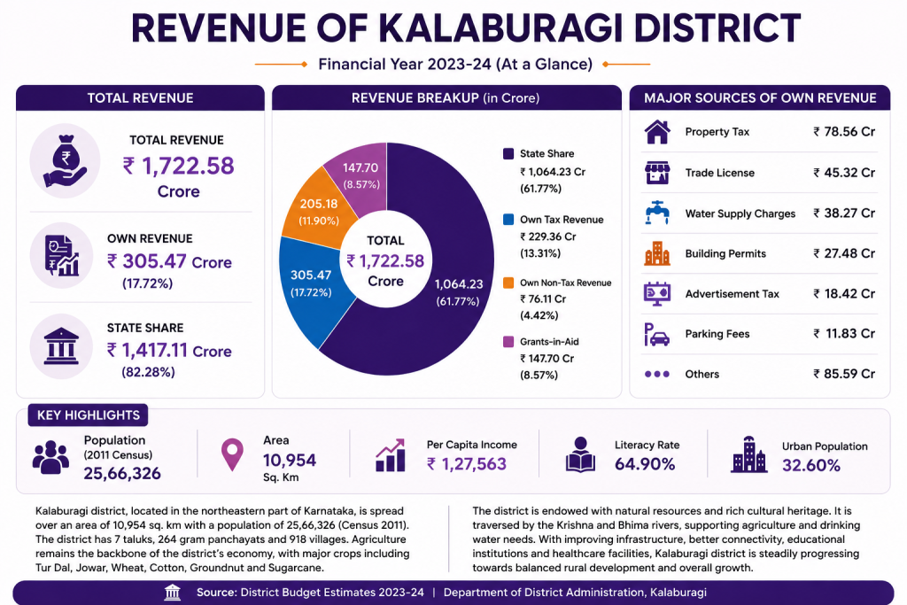
Kalaburagi District has a predominantly agriculture-based economy, supported by crops such as Tur Dal, Jowar, Wheat, Cotton, Groundnut and Sugarcane. The district’s strategic location in northeastern Karnataka, along with its growing urban centre, educational institutions, healthcare facilities and commercial activities, contributes to its overall economic development. Kalaburagi’s Tur Dal is particularly important to the local agricultural economy and has a GI-recognised identity.
The district is also witnessing gradual growth in infrastructure, industries, trade, education and public development programmes. Government investment through regional development initiatives, irrigation projects and rural-development programmes continues to support economic activity and improve opportunities for communities across the district.